Helsinki transport map
You can find on this page the Helsinki transport map to print and to download in PDF. The Helsinki transportation map presents the transports network and transport zones of the transit of Helsinki in Uusimaa - Finland.
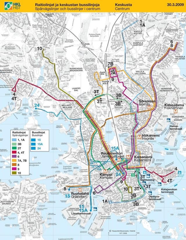
Helsinki transports map
The Helsinki transport map shows all means of transportation in Helsinki. This transports map of Helsinki will allow you to move easily with public transport of Helsinki in Uusimaa - Finland. The Helsinki transportation map is downloadable in PDF, printable and free.
Public transport in Helsinki consists of bus, tram, metro, train, and ferry services as you can see in Helsinki transports map. The system is managed by Helsinki City Transport (HKL) for the lines that remain in Helsinki and by Helsinki Metropolitan Area Council (YTV) for the routes running in several municipalities, mostly including the surrounding municipalities of Espoo, Vantaa and Kauniainen. Helsinki diverse public transport system consists of trams, light commuter rail, the subway, bus lines and two ferry lines. The Helsinki Metropolitan Area Council manages traffic to neighbouring municipalities. Today, Helsinki is the only city in Finland to have trams or subway trains. There used to be two other cities in Finland with trams: Turku and Viipuri (Vyborg). However, Turku abandoned trams in 1972 and Viipuri (at that time already part of the Soviet Union) abandoned them in 1957. A ferry line connects in 15 minutes the Helsinki Market Square (Kauppatori) to the Suomenlinna Fortress (Iso Mustasaari). The ferries run from 6:20 a.m. to 2:00 a.m. with two or three departures per hour in season.
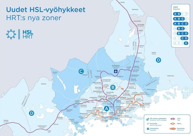
Helsinki zone map
The Helsinki zone map shows all transport zones in Helsinki. This zone map of Helsinki will allow you to know the prices of public transport of Helsinki in Uusimaa - Finland. The Helsinki zones of transports map is downloadable in PDF, printable and free.
The public transportation system has three zones as you can see in Helsinki zone map: internal, regional (two zones) and the whole region (three zones). Internal covers a single city and regional the Helsinki metropolitan area. The whole region covers the Helsinki metropolitan area and additionally Kerava and Kirkkonummi municipalities. The different areas are symbolised by different colours: Blue signifies Helsinki, green signifies Espoo and Kauniainen, red signifies Vantaa and purple signifies the entire metropolitan area. Helsinki Card holders can travel free of charge on public transportation depending on their card within zones A/ B or A/B/C.