Helsinki neighborhood map
You can find on this page the Helsinki neighborhood map to print and to download in PDF. The Helsinki districts map presents quarters, region, suburbs and surrounding area of Helsinki in Uusimaa - Finland.
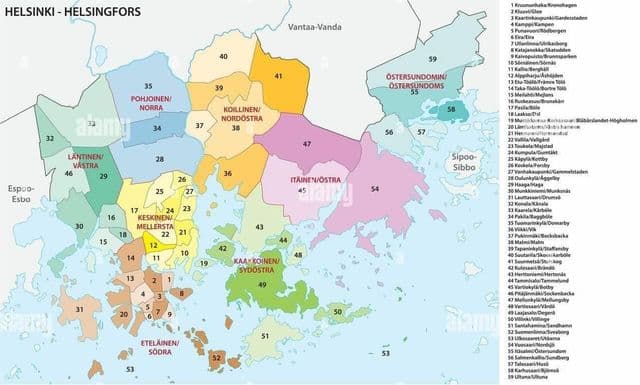
Helsinki neighborhoods map
The Helsinki neighborhoods map shows region and suburbs of Helsinki areas. This neighborhood map of Helsinki will allow you to discover quarters and surrounding area of Helsinki in Uusimaa - Finland. The Helsinki quarters map is downloadable in PDF, printable and free.
The division into neighbourhoods is the official division created by the city council and used for city planning and other similar purposes. Most of the neighbourhoods have existed since the 19th century as numbered parts of the city, and official names were assigned to them in 1959. Five neighbourhoods (numbers 55 – 59) were annexed on 1 January 2009. Today, each neighbourhood is identified by both a two-digit number between 01 and 59 and an official name in both Finnish and Swedish (in some cases they may be identical) as its shown in Helsinki neighborhoods map. Neighbourhoods are further divided into quarters (osa-alue) and sectors (pienalue), numbered with three and four digits respectively. Sectors divide further into individual blocks and properties.
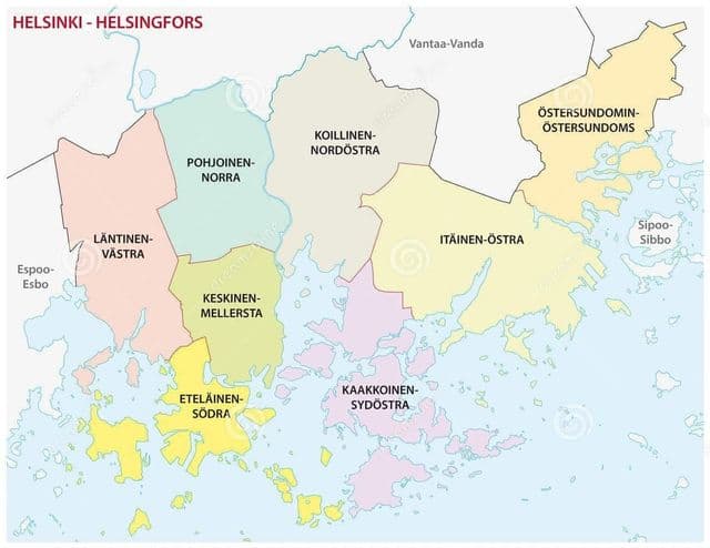
Helsinki districts map
The Helsinki districts map shows all quarters and suburbs of Helsinki. This district map of Helsinki will allow you to discover areas and the region of Helsinki in Uusimaa - Finland. The Helsinki districts map is downloadable in PDF, printable and free.
Helsinki as you can see in Helsinki districts map is divided into 33 districts ( peruspiiri , distrikt ) to facilitate the coordination of public services. The districts, which may include several neighborhoods, are organized into seven major districts ( suurpiiri , stordistrikt ). Different quarters of a neighborhood may belong to different districts, but individual quarters are never divided between neighborhoods. The district division was created by a decision of the city council on 13 December 1982, when the number of different subdivisions used by different municipal departments was seen as confusing and problematic. Before the reform, in 1980, there were 101 different divisions used by the departments, of which only 17 corresponded to the official neighborhood division. The new districts came to use within all providers of public services by 1986.